دوست عزیز، به سایت علمی نخبگان جوان خوش آمدید

مشاهده این پیام به این معنی است که شما در سایت عضو نیستید، لطفا در صورت تمایل جهت عضویت در سایت علمی نخبگان جوان اینجا کلیک کنید.

توجه داشته باشید، در صورتی که عضو سایت نباشید نمی توانید از تمامی امکانات و خدمات سایت استفاده کنید.
صفحه 2 از 5 نخستنخست 12345 آخرینآخرین
نمایش نتایج: از شماره 11 تا 20 , از مجموع 49

موضوع: دانلود نرم افزارهای تخصصی مهندسی آب و فاضلاب و محیط زیست

  1. #11
    کاربر اخراج شده
    رشته تحصیلی
    مهندسی عمران
    نوشته ها
    0
    ارسال تشکر
    11,136
    دریافت تشکر: 25,270
    قدرت امتیاز دهی
    0
    Array
    M@hdi42's: لبخند

    پیش فرض پاسخ : دانلود نرم افزارهای تخصصی مهندسی آب و فاضلاب و محیط زیست

    CE CALC - Civil Calculator 1.0
    Civil Calculator - Civil Engineering calculation software, performs calculations for hydrology, open channels, culverts, gravity sewer, pressure pipe, traffic, road geometry, topo surveying, earthwork, pavement, concrete floors and unit conversions. Available in two versions x86 for 32 bit architecture and x64 for 64 bit architecture.
    File Size :
    15.26 MB
    Download Link 1
    http://www.topshareware.com/download...C+Trialx86.exe

  2. #12
    کاربر اخراج شده
    رشته تحصیلی
    مهندسی عمران
    نوشته ها
    0
    ارسال تشکر
    11,136
    دریافت تشکر: 25,270
    قدرت امتیاز دهی
    0
    Array
    M@hdi42's: لبخند

  3. #13
    کاربر اخراج شده
    رشته تحصیلی
    مهندسی عمران
    نوشته ها
    0
    ارسال تشکر
    11,136
    دریافت تشکر: 25,270
    قدرت امتیاز دهی
    0
    Array
    M@hdi42's: لبخند

    پیش فرض پاسخ : دانلود نرم افزارهای تخصصی مهندسی آب و فاضلاب و محیط زیست

    Storm Water Management Model Version 5.0.018


    توضیحات:
    Description

    The EPA Storm Water Management Model (SWMM) is a dynamic rainfall-runoff simulation model used for single event or long-term (continuous) simulation of runoff quantity and quality from primarily urban areas. The runoff component of SWMM operates on a collection of subcatchment areas that receive precipitation and generate runoff and pollutant loads. The routing portion of SWMM transports this runoff through a system of pipes, channels, storage/treatment devices, pumps, and regulators. SWMM tracks the quantity and quality of runoff generated within each subcatchment, and the flow rate, flow depth, and quality of water in each pipe and channel during a simulation period comprised of multiple time steps.

    SWMM was first developed in 1971, and has since undergone several major upgrades since then. It continues to be widely used throughout the world for planning, analysis and design related to stormwater runoff, combined sewers, sanitary sewers, and other drainage systems in urban areas, with many applications in non-urban areas as well. The current edition, Version 5, is a complete re-write of the previous release. Running under Windows, SWMM 5 provides an integrated environment for editing study area input data, running hydrologic, hydraulic and water quality simulations, and viewing the results in a variety of formats. These include color-coded drainage area and conveyance system maps, time series graphs and tables, profile plots, and statistical frequency analyses.

    This latest re-write of SWMM was produced by the Water Supply and Water Resources Division of the U.S. Environmental Protection Agency's National Risk Management Research Laboratory in a joint development effort with CDM, Inc., a global consulting, engineering, construction, and operations firm.

    Top of page
    Capabilities

    SWMM accounts for various hydrologic processes that produce runoff from urban areas. These include:

    * time-varying rainfall
    * evaporation of standing surface water
    * snow accumulation and melting
    * rainfall interception from depression storage
    * infiltration of rainfall into unsaturated soil layers
    * percolation of infiltrated water into groundwater layers
    * interflow between groundwater and the drainage system
    * nonlinear reservoir routing of overland flow.

    Spatial variability in all of these processes is achieved by dividing a study area into a collection of smaller, homogeneous subcatchment areas, each containing its own fraction of pervious and impervious sub-areas. Overland flow can be routed between sub-areas, between subcatchments, or between entry points of a drainage system.

    SWMM also contains a flexible set of hydraulic modeling capabilities used to route runoff and external inflows through the drainage system network of pipes, channels, storage/treatment units and diversion structures. These include the ability to:

    * handle drainage networks of unlimited size
    * use a wide variety of standard closed and open conduit shapes as well as natural channels
    * model special elements such as storage/treatment units, flow dividers, pumps, weirs, and orifices
    * apply external flows and water quality inputs from surface runoff, groundwater interflow, rainfall-dependent infiltration/inflow, dry weather sanitary flow, and user-defined inflows
    * utilize either kinematic wave or full dynamic wave flow routing methods
    * model various flow regimes, such as backwater, surcharging, reverse flow, and surface ponding
    * apply user-defined dynamic control rules to simulate the operation of pumps, orifice openings, and weir crest levels

    In addition to modeling the generation and transport of runoff flows, SWMM can also estimate the production of pollutant loads associated with this runoff. The following processes can be modeled for any number of user-defined water quality constituents:

    * dry-weather pollutant buildup over different land uses
    * pollutant washoff from specific land uses during storm events
    * direct contribution of rainfall deposition
    * reduction in dry-weather buildup due to street cleaning
    * reduction in washoff load due to BMPs
    * entry of dry weather sanitary flows and user-specified external inflows at any point in the drainage system
    * routing of water quality constituents through the drainage system
    * reduction in constituent concentration through treatment in storage units or by natural processes in pipes and channels

    Top of page
    Applications

    Since its inception, SWMM has been used in thousands of sewer and stormwater studies throughout the world. Typical applications include:

    * design and sizing of drainage system components for flood control
    * sizing of detention facilities and their appurtenances for flood control and water quality protection
    * flood plain mapping of natural channel systems (SWMM 5 is a FEMA-approved model for NFPI studies)
    * designing control strategies for minimizing combined sewer overflows
    * evaluating the impact of inflow and infiltration on sanitary sewer overflows
    * generating non-point source pollutant loadings for waste load allocation studies
    * evaluating the effectiveness of BMPs for reducing wet weather pollutant loadings

    صفحه دانلود:
    http://www.epa.gov/ednnrmrl/models/swmm/

  4. #14
    کاربر اخراج شده
    رشته تحصیلی
    مهندسی عمران
    نوشته ها
    0
    ارسال تشکر
    11,136
    دریافت تشکر: 25,270
    قدرت امتیاز دهی
    0
    Array
    M@hdi42's: لبخند

    پیش فرض پاسخ : دانلود نرم افزارهای تخصصی مهندسی آب و فاضلاب و محیط زیست

    نرم‌افزار برداشت هيدروگرافی Hypack(رشته نقشه برداری - آبنگاری)
    نرم‌افزار برداشت هيدروگرافی Hypack

    نرم‌افزار Hypack يك نرم‌افزار برداشت هيدروگرافی است كه در سراسر جهان بصورت گسترده كاربرد دارد و تمام ابزار لازم برای طراحی، جمع‌آوری داده‌ها، پردازش و محاسبات آنها و توليد نقشه‌های نهايی را در اختيار كاربر قرار می‌دهد، در جمع‌آوری داده‌های هيدروگرافی، محيط زيستی و يا پروژه‌های مهندسی. گستره قابل استفاده اين نرم‌افزار از يك قايق كوچك با يك دستگاه GPS و يك اكوساندر تك پرتو تا كشتی‌های حاوی سامانه‌ها و حسگرهای تحت محيط شبكه را در بر می‌گيرد.
    پروژه ايجاد شده در Hypack شامل كليه اطلاعات فنی لازم بوده و كاربر مي‌تواند به سهولت مبنای ژئودزی و سيستم مختصات مورد نياز را انتخاب يا تعريف نموده و در صورت لزوم از فايلهای TIF، DXF يا DGN بعنوان تصاوير زمينه كه در مراحل مختلف كار ديده می‌شوند استفاده كند.
    بخش برداشت نرم‌افزار Hypack شامل راه‌اندازهای لازم برای بيش از 200 دستگاه جانبی از قبيل GPSها، اكوساندرها و حسگرها و ساير وسايل بوده و اطلاعات دريافتی با دقت بالا (سريعتر از يك هزارم ثانيه) جمع شده و اين اطلاعات را می‌توان در محيط شبكه به يك رايانه ديگر نيز ارسال نمود. نمايش بلادرنگ، توابع كنترل كيفيت و جمع‌آوری داده از اغلب سامانه‌های چندپرتو از قبيل محصولات Atlas، Odom، Reson، Sea Beam و Simrad نيز امكانپذير می‌باشد.

    بخش ويرايش نرم‌افزار برای بررسی سريع اطلاعات برداشت شده بكار می‌رود و اين اطلاعات بطور همزمان به صورتهای پلان، پروفيل و ليست نمايش داده ‌شده و تصحيحات مربوط به سطح آب نيز كه از اطلاعات دريافتی از GPS بدست آمده اعمال می‌شوند.
    پشتيبانی از سامانه‌های Side Scan Sonar نيز فراهم شده و از كليه دستگاههای آنالوگ و برخی از انواع ديجيتال می‌توان استفاده کرد.
    توانايی توليد نقشه‌های نهايی، اين نرم‌افزار را از ساير نرم‌افزارهای مشابه متمايز مي‌كند: بخش پلات با امكان ايجاد و نمايش شيتهای حرفه‌ای و ارسال به ساير نرم‌افزارها، محاسبات احجام و ساخت سطوح TIN قابل استفاده در تهيه منحنی ميزان و نمايش سطوح سه بعدی. همچنين مي‌توان يك دوربين فرضی را در مسير مورد مطالعه به پرواز درآورده و تصاوير حاصل از سطح برداشت شده را به صورت يك فايل AVI در اختيار كارفرما قرار داد.
    امكان ارسال اطلاعات به فرمتهای DXF يا DGN و همچنين دريافت خطوط طراحی‌شده در ساير نرم‌افزارها با اين فرمتها در Hypack از ديگر قابليتهای اين نرم‌افزار است.

    اطلاعات بيشتر در خصوص اين نرم افزار:
    http://www.hypack.com/new/Sales/Prod...6/Default.aspx
    فايلهای آموزشی نرم افزار:
    http://www.hypack.com/new/Support/Tr...8/Default.aspx
    اطلاعات بيشتر:
    http://www.gps1.com/hypack_max.html
    لینک اتصال دانلود نرم افزار:
    http://support.hypack.com/support/in...nloads&_a=view
    منبع :وبلاگ نقشه برداري جامع و حرفه ای

  5. #15
    کاربر اخراج شده
    رشته تحصیلی
    مهندسی عمران
    نوشته ها
    0
    ارسال تشکر
    11,136
    دریافت تشکر: 25,270
    قدرت امتیاز دهی
    0
    Array
    M@hdi42's: لبخند

    پیش فرض پاسخ : دانلود نرم افزارهای تخصصی مهندسی آب و فاضلاب و محیط زیست

    نرم افزار طراحی خطوط آب و فاضلاب Piping System Fluid Flow 3.09
    توضیحات:

    A truly original software program for the design and optimization of pipe networks,
    transporting compressible, incompressible, gas-liquid two phase, settling slurries or non-Newtonian fluids.

    The efficient and accurate modelling of your networks is essential to the design of energy efficient, safe, reliable flow systems that are easy to operate and maintain.

    This product is used succesfully in many diverse industries to model new and existing systems, size pipes, select boosters, controllers and other fluid equipment.

    بند انگشتی, برای دیدن عکس به صورت کامل بر روی آن کلیک نمایید

    بند انگشتی, برای دیدن عکس به صورت کامل بر روی آن کلیک نمایید

    بند انگشتی, برای دیدن عکس به صورت کامل بر روی آن کلیک نمایید

    بند انگشتی, برای دیدن عکس به صورت کامل بر روی آن کلیک نمایید

    لینک دانلود:
    http://rapidshare.com/files/78357844...w3_all.rar.htm
    پسورد:
    www.civilstars.com

  6. #16
    کاربر اخراج شده
    رشته تحصیلی
    مهندسی عمران
    نوشته ها
    0
    ارسال تشکر
    11,136
    دریافت تشکر: 25,270
    قدرت امتیاز دهی
    0
    Array
    M@hdi42's: لبخند

    پیش فرض پاسخ : دانلود نرم افزارهای تخصصی مهندسی آب و فاضلاب و محیط زیست

    PipeData-Pro v8.0.27
    بند انگشتی, برای دیدن عکس به صورت کامل بر روی آن کلیک نمایید

    توضیحات:

    - PipeData-PRO is an easy to use program, giving access to a vast knowledge-base on pipe, pipe fittings, flanges and valves
    - Information is quick and easy to find us clearly presented on screen in tabular and schematic form
    - PipeData-PRO is an essential electronic reference for engineers preparing welding procedures and qualification tests
    - PipeData-PRO is a useful dimensional reference for engineers undertaking re-ratings and fitness for service (FFS) assessments


    KEY FEATURES

    PipeData-PRO increases efficiency by lightening the burden of 'looking-up' piping information. Information can be found by navigation using the drop-down menus or by a search utility.

    Display units can be set to inches/millimetres and weights to pounds/kilograms.

    The program has been reviewed by the committee members of ASME B31 Mechanical Design Committee, MSS-SP-97 Committee, and several committees to "right justify" ASME codes with ISO to properly metrify US standards.

    The software is updated to comply with changes in piping specifications and Microsoft Windows operating system. Data and functionality are also added at regular intervals. These incremental enhancements are free to registered users and are available as inter-version updates from

    لینک دانلود:
    http://uploading.com/files/72ade31c/...th+Serial.rar/
    لینک های کمکی:
    http://sia125.dl.rapidbaz.com/TpTc/P...lstars.com.rar
    http://www.megashare.com/2418442
    http://1.bigfilehost.com/en/file/641...s-com-rar.html
    پسورد:
    www.civilstars.com

  7. #17
    کاربر اخراج شده
    رشته تحصیلی
    مهندسی عمران
    نوشته ها
    0
    ارسال تشکر
    11,136
    دریافت تشکر: 25,270
    قدرت امتیاز دهی
    0
    Array
    M@hdi42's: لبخند

    پیش فرض پاسخ : دانلود نرم افزارهای تخصصی مهندسی آب و فاضلاب و محیط زیست

    دانلود جدید ترین ورژن Bentley WaterGEMS V8i 05.11.01.32 بصورت تریال
    بند انگشتی, برای دیدن عکس به صورت کامل بر روی آن کلیک نمایید

    WaterGEMS is an easy-to-use hydraulic and water quality modeling solution for water distribution systems.
    It features advanced interoperability, model building, optimization, and asset management tools. WaterGEMS runs on your choice of four platforms (stand alone, Microstation, AutoCAD, or ArcGIS). From fire-flow and constituent-concentration analyses, to energy-consumption and capital-cost management, WaterGEMS helps engineers and utilities analyze, design, and optimize water distribution systems. Water utilities, municipalities, and design engineering firms trust WaterGEMS as a reliable, resource-saving, decision-support tool for their water infrastructure. Criticality Analysis allows users to find the weak links in a water system and assess the adequacy of isolation valves. They depend upon its robust hydraulic analysis, practical model management, eloquent result interpretation tools, and unrivaled ease of use.


    لینک دانلود:
    ftp://ftp2.bentley.com/dist2/intel/v...08110132en.exe
    منبع

  8. #18
    کاربر اخراج شده
    رشته تحصیلی
    مهندسی عمران
    نوشته ها
    0
    ارسال تشکر
    11,136
    دریافت تشکر: 25,270
    قدرت امتیاز دهی
    0
    Array
    M@hdi42's: لبخند

    پیش فرض پاسخ : دانلود نرم افزارهای تخصصی مهندسی آب و فاضلاب و محیط زیست


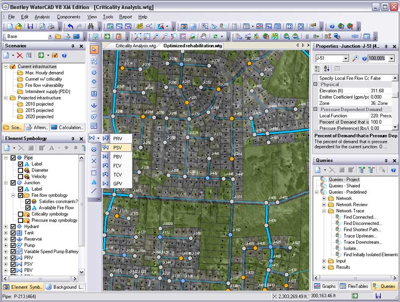
    دانلود آخرین نسخه نرم افزار آب و فاضلاب Bentley WaterCAD V8i 08.11.01.32 همراه با کرک
    بند انگشتی, برای دیدن عکس به صورت کامل بر روی آن کلیک نمایید


    WaterGEMS is an easy-to-use hydraulic and water quality modeling solution for water distribution systems.
    It features advanced interoperability, model building, optimization, and asset management tools. WaterGEMS runs on your choice of four platforms (stand alone, Microstation, AutoCAD, or ArcGIS). From fire-flow and constituent-concentration analyses, to energy-consumption and capital-cost management, WaterGEMS helps engineers and utilities analyze, design, and optimize water distribution systems. Water utilities, municipalities, and design engineering firms trust WaterGEMS as a reliable, resource-saving, decision-support tool for their water infrastructure. Criticality Analysis allows users to find the weak links in a water system and assess the adequacy of isolation valves. They depend upon its robust hydraulic analysis, practical model management, eloquent result interpretation tools, and unrivaled ease of use.

    لینک دانلود:
    ftp://ftp2.bentley.com/dist2/intel/v...08110132en.exe
    کرک از پیوست
    منبع

  9. #19
    کاربر اخراج شده
    رشته تحصیلی
    مهندسی عمران
    نوشته ها
    0
    ارسال تشکر
    11,136
    دریافت تشکر: 25,270
    قدرت امتیاز دهی
    0
    Array
    M@hdi42's: لبخند

    پیش فرض پاسخ : دانلود نرم افزارهای تخصصی مهندسی آب و فاضلاب و محیط زیست


    دانلود نرم افزار Bentley watercad 08.11.00.30
    بند انگشتی, برای دیدن عکس به صورت کامل بر روی آن کلیک نمایید

    بند انگشتی, برای دیدن عکس به صورت کامل بر روی آن کلیک نمایید

    توضیحات برنامه Model hydraulics, operations, fire flow, criticality, and water quality with ease using your favorite environment.
    Customize your WaterCAD with advanced calibration, automatic design, and
    skeletonization modules as your modeling requirements grow.


    نحوه نصب:

    Test with Bentley.liclib.dll from ProSteel.V8i.32Bit.for.AutoCAD.2004-2009.v19.11.08.MULTiLANGUAGE-SUBSTANCE

    1. Copy Bentley.liclib.dll to <installdir>\...\Prg
    2. Start WTCAD-registry.bat and generate -> Registry_WaterCAD.reg
    3. Double-click (activate) Registry_WaterCAD.reg
    4. Start WaterCAD & Evaluate

    لینک دانلود:
    http://rapidshare.com/files/28987513...0.30.part1.rar
    http://rapidshare.com/files/28997527...0.30.part2.rar
    http://rapidshare.com/files/29001840...0.30.part3.rar
    پسوورد:
    http://www.k-e-g.org

    منبع
    http://www.k-e-g.org/
    به نقل از :
    http://www.civilstars.com

  10. #20
    کاربر اخراج شده
    رشته تحصیلی
    مهندسی عمران
    نوشته ها
    0
    ارسال تشکر
    11,136
    دریافت تشکر: 25,270
    قدرت امتیاز دهی
    0
    Array
    M@hdi42's: لبخند

    پیش فرض پاسخ : دانلود نرم افزارهای تخصصی مهندسی آب و فاضلاب و محیط زیست

    نرم افزار Bentley Culvert Master 3.2
    توضیحات:
    Bentley CulvertMaster helps civil engineers design and analyze simple culverts or complex embankment cross-drain systems.
    You can use Bentley CulvertMaster to:
    · Create design trials of single or multi-barreled culvert components, with a choice of cross-sectional shapes including circular, arch, box, and elliptical.
    · Analyze various designs for complex embankment cross-drain systems comprised of one or more culvert components and/or embankment overtopping.
    · Calculate watershed discharge rates using rainfall tables, equations, or Hydro-35 data, and plot rainfall intensity-duration-frequency (IDF) curves.
    · Generate professional-looking reports and graphs.

    Bentley CulvertMaster provides flexible tools that you can use for all phases of your project:

    Quick Culvert Calculator
    Use the Quick Culvert Calculator whenever you need a quick answer for a simple culvert design or analysis. This worksheet style dialog requires the minimum amount of descriptive input information to solve for discharge, headwater elevation, or culvert size. The Quick Culvert Calculator is a terrific tool for verifying the performance of an existing culvert crossing or for spot-checking design calculations!

    Culvert Designer/Analyzer - Design mode
    For a new design, you supply basic site and roadway data that will apply for a specific culvert crossing. You can then develop any number of culvert design trials for the specific site and roadway embankment conditions. You have options for computing watershed discharge, design headwater, tailwater conditions, stream channel grades and embankment slopes. In Design mode, you create individual culvert trials and solve for:
    · Size of a culvert of a specified shape, material, and roughness to pass the design discharge under design elevation headwater conditions;
    · Discharge for a specific culvert under design elevation headwater; or,
    · Elevation headwater for a specific culvert under design discharge conditions.

    Culvert Designer/Analyzer - Analysis mode
    For Analysis, you have options for computing watershed discharge, tailwater conditions and stream channel grades, and roadway profiles for overtopping. You then specify each of the culvert structures that work together to provide cross-drainage at the site. You may also import a design trial culvert component into the culvert set if you want to evaluate the effects of adding supplemental structures. Use the New Analysis option if you are:
    · Verifying the hydraulic performance of existing culverts;
    · Analyzing complex situations such as main-stream culverts working in combination with relief culverts in overbank areas;
    · Performing road overtopping analysis of existing culverts or new designs; or,
    · Supplementing existing culvert structures to correct inadequate capacities resulting from urbanizing watersheds or undersized cross-drain conditions.

    لینک دانلود:

    http://www.mediafire.com/?myatduzav3n
    یا
    http://www.megaupload.com/?d=W7G6B67R
    پسورد:
    FromCivilEA
    کرک را از پیوست دریافت نمایید
    منبع

صفحه 2 از 5 نخستنخست 12345 آخرینآخرین

اطلاعات موضوع

کاربرانی که در حال مشاهده این موضوع هستند

در حال حاضر 1 کاربر در حال مشاهده این موضوع است. (0 کاربران و 1 مهمان ها)

موضوعات مشابه

  1. پاسخ ها: 19
    آخرين نوشته: 23rd August 2010, 03:59 AM
  2. پاسخ ها: 0
    آخرين نوشته: 11th December 2008, 04:30 AM

کلمات کلیدی این موضوع

مجوز های ارسال و ویرایش

  • شما نمیتوانید موضوع جدیدی ارسال کنید
  • شما امکان ارسال پاسخ را ندارید
  • شما نمیتوانید فایل پیوست کنید.
  • شما نمیتوانید پست های خود را ویرایش کنید
  •