دوست عزیز، به سایت علمی نخبگان جوان خوش آمدید

مشاهده این پیام به این معنی است که شما در سایت عضو نیستید، لطفا در صورت تمایل جهت عضویت در سایت علمی نخبگان جوان اینجا کلیک کنید.

توجه داشته باشید، در صورتی که عضو سایت نباشید نمی توانید از تمامی امکانات و خدمات سایت استفاده کنید.
صفحه 1 از 5 12345 آخرینآخرین
نمایش نتایج: از شماره 1 تا 10 , از مجموع 49

موضوع: دانلود نرم افزارهای تخصصی مهندسی آب و فاضلاب و محیط زیست

  1. #1
    کاربر اخراج شده
    رشته تحصیلی
    مهندسی عمران
    نوشته ها
    0
    ارسال تشکر
    11,136
    دریافت تشکر: 25,270
    قدرت امتیاز دهی
    0
    Array
    M@hdi42's: لبخند

    smilee1 دانلود نرم افزارهای تخصصی مهندسی آب و فاضلاب و محیط زیست

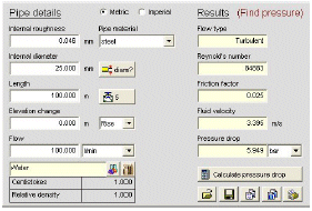
    جهت دسترسی بهتر کاربران به نرم افزارها ، نرم افزارهای تخصصی آب و فاضلاب و مهندسی محیط زیست در این تاپیک ارایه میشود. از کاربران درخواست میشود از این پس این مساله را رعایت و اگر نرم افزاری مربوط به این رشته را میخواهند در سایت برای دانلود قرار دهند از طریق همین تاپیک این کار را انجام دهند.
    البته غیر از این تاپیک و قبل از تاریخ مذکور نرم افزارهای متعددی در این زمینه در سایت قرار گرفته است که به دلیل تعداد زیاد آنها امکان قرارگیری دوباره آنها در این تاپیک نیست

  2. #2
    کاربر اخراج شده
    رشته تحصیلی
    مهندسی عمران
    نوشته ها
    0
    ارسال تشکر
    11,136
    دریافت تشکر: 25,270
    قدرت امتیاز دهی
    0
    Array
    M@hdi42's: لبخند

    پیش فرض پاسخ : دانلود نرم افزارهای تخصصی مهندسی آب و فاضلاب و محیط زیست

    دانلود نرم افزار طراحی خطوط آب و فاضلاب Fathom v7.0
    بند انگشتی, برای دیدن عکس به صورت کامل بر روی آن کلیک نمایید


    توضیحات:
    AFT Fathom 7.0 provides comprehensive,incompressible pipe flow analysis and system
    modeling capabilities combined with ease-of-use.
    Addressing open and closed loop systems, AFT Fathom includes a built-in library of fluids and fittings,
    variable model configurations, pump and control valve modeling and much more. With the optional
    Chempak add-in, a thermo-physical database of over 600 fluids is available to further expand the
    envelope of your analysis and design. AFT Fathom goes beyond the boundaries of traditional pipe flow
    analysis, with thermal analysis capabilities including piping heat transfer, heat exchanger
    modeling and varying fluid properties.


    Use any serial when asked or 3471502010.

    لینک دانلود:
    http://dl.dropbox.com/u/6330477/lera...2.11.part1.exe
    http://dl.dropbox.com/u/6330477/lera...2.11.part2.rar
    http://dl.dropbox.com/u/6330477/lera...2.11.part3.rar
    http://dl.dropbox.com/u/6330477/lera...2.11.part4.rar
    پسورد:
    www.civilstars.com

  3. #3
    کاربر اخراج شده
    رشته تحصیلی
    مهندسی عمران
    نوشته ها
    0
    ارسال تشکر
    11,136
    دریافت تشکر: 25,270
    قدرت امتیاز دهی
    0
    Array
    M@hdi42's: لبخند

    پیش فرض پاسخ : دانلود نرم افزارهای تخصصی مهندسی آب و فاضلاب و محیط زیست

    دانلود نرم افزار Pipe Flow Wizard 1.12

    توضیحات:

    Pipe Flow Wizard is able to perform four different calculations depending on the known information.


    PRESSURE DROP CALCULATION
    FLOW RATE CALCULATION
    INTERNAL DIAMETER CALCULATION
    PIPE LENGTH CALCULATION

    Pipe Flow Wizard will calculate results for LIQUIDS or COMPRESSED GASES.
    A database of viscosity and density for a number of common fluids is included


    لینکهای دانلود:
    http://rapidshare.com/files/381406723/PFW1.12.rar.html
    پسورد : FromCivilEA
    http://www.filesonic.com/file/1603922694/PFW1.12.rar
    http://www.multiupload.com/KVEDERU0JD
    https://rapidshare.com/#!download|103tl|2647044132|PFW1.12.rar|2416|R~A5C1 052E650405C85A63470EF5454621
    http://www.megaupload.com/?d=0H6UF6N1
    http://depositfiles.com/en/files/9h115cym4
    http://hotfile.com/dl/125972239/e1b5...W1.12.rar.html
    http://www.zshare.net/download/933651526eea4a94/
    http://uploading.com/files/1f8me264/PFW1.12.rar/
    http://www.filesonic.com/file/1604187131/PFW1.12.rar
    http://www.fileserve.com/file/TVm5tdG

    http://dl.dropbox.com/u/6330477/leran/PipeFW1.12.exe
    پسورد:
    www.civilstars.com

  4. #4
    کاربر اخراج شده
    رشته تحصیلی
    مهندسی عمران
    نوشته ها
    0
    ارسال تشکر
    11,136
    دریافت تشکر: 25,270
    قدرت امتیاز دهی
    0
    Array
    M@hdi42's: لبخند

    پیش فرض پاسخ : دانلود نرم افزارهای تخصصی مهندسی آب و فاضلاب و محیط زیست

    دانلود نرم افزار 1.11 pipe Flow Advisor


    Flow Advisor can be used to estimate water flow rates from various open channels, closed channels and differently shaped supply tanks. It can calculate:
    Open Channel Flow and Flow in Part Filled Pipes
    Water Flow Rates
    Time taken to empty tanks
    Volume, Capacity, Weight and Expansion
    Flow Advisor's Materials Database is included with density and coefficient of expansion of many common materials..

    A Fluid Database is included with density of common fluids.


    [ Download Free Trial ]
    OPEN CHANNEL FLOW AND PART FILLED PIPES

    Open-channel flow occurs when a liquid flows due to gravity. Usually the flowing liquid has a free surface, as in a channel, flume or partially full pipe. The liquid is not under pressure, other than atmospheric pressure. Many formulae have been developed to estimate the flow rate in open-channels, the Manning formula has become widely accepted as the usual method of estimating flow rate.
    WATER FLOW RATE CALCULATION

    The Manning formula uses a coefficient to correct for the type of channel in use. The cross-sectional area of the flow, the wetted perimeter of the flow and the slope ratio must be calculated. The results are more accurate if the flow cross-section, velocity, depth and slope are constant (steady flow). The flow rate estimates are applicable to water or fluids similar to water.
    TIME TAKEN TO EMPTY TANKS

    The flow rate from a tank outlet will be dependant on the orifice size, orifice type and the head of fluid above the outlet position. The additon of an oulet pipe may restrict the oulet flow rate unless the outlet pipe is relatively short. As the tank empties the fluid head will reduce progressively, reducing the outlet flow rate. The shape of the tank will also affect the time taken to empty, as changes in shape will affect the rate of change of the fluid head available.
    VOLUME, CAPACITY, WEIGHT & EXPANSION

    The inner volume, fluid capacity, weight and expansion of various pipes, sections, channels and tanks can be calculated. The weight of a pipe, channel or tank in various material constructions (steel, wood, aluminium, brass etc.) and the fluid contents may be displayed by entering the appropriate dimensions and choosing the material and fluid type.

    لینک دانلود:
    http://dl.dropbox.com/u/6330477/leran/PipeFA1.11.exe

    پسوورد:
    www.civilstars.com

  5. #5
    کاربر اخراج شده
    رشته تحصیلی
    مهندسی عمران
    نوشته ها
    0
    ارسال تشکر
    11,136
    دریافت تشکر: 25,270
    قدرت امتیاز دهی
    0
    Array
    M@hdi42's: لبخند

    پیش فرض پاسخ : دانلود نرم افزارهای تخصصی مهندسی آب و فاضلاب و محیط زیست

    RocsciencePillar v3.04
    RocsciencePillar v3.04
    نرم افزار ارزیابی پایداری سطوح یا ستون های نگاه دارنده سطح و رویه های چند لایه


    لینک دانلود:
    http://dl.dropbox.com/u/6330477/leran/RocsciencePillar v3.04.exe
    پسورد:
    www.civilstars.com

  6. #6
    کاربر اخراج شده
    رشته تحصیلی
    مهندسی عمران
    نوشته ها
    0
    ارسال تشکر
    11,136
    دریافت تشکر: 25,270
    قدرت امتیاز دهی
    0
    Array
    M@hdi42's: لبخند

    پیش فرض پاسخ : دانلود نرم افزارهای تخصصی مهندسی آب و فاضلاب و محیط زیست

    دانلود نرم افزار Rocscience RocFall v4.039
    بند انگشتی, برای دیدن عکس به صورت کامل بر روی آن کلیک نمایید


    توضیحات:
    Statistical Analysis of Rockfalls

    RocFall is a statistical analysis program designed to assist with assessment of slopes at risk for rockfalls. Energy, velocity and "bounce height" envelopes for the entire slope are determined by the program, as is the location of rock endpoints. Distributions of energy, velocity and bounce-height are also calculated along the slope profile; Distributions can be graphed and comprehensive statistics are automatically calculated.
    RocFall can also assist in determining remedial measures: the material properties of each slope segment can be changed allowing for comparison of results. Information about the kinetic energy and location of impact on a barrier can help determine the capacity, size and location of barriers. RocFall provides various ways of interacting with other Windows programs. All input and output data (formatted in tabular form) and screen captures, can be "pasted" into a word processor for speedy report writing. RocFall also allows "raw" data (e.g. the impact location on a barrier) to be "pasted" into a spreadsheet for more detailed analysis. (e.g. determining what fraction of the impact locations were above a certain height or fitting a probability distribution to the data).

    To assist with determining coefficients of restitution, RocFall 4.0 now includes a large table of coefficients of restitution that was compiled after an extensive literature search. RocFall also provides a Material Wizard that uses statistics to determine the coefficient of restitution (RN) for a material, based on the back-calculation of rock endpoints. Rock paths can be filtered. (e.g. you can right-click on a barrier and select, from the many impacts on the barrier, 10 paths that had the highest velocity when they contacted the barrier).

    RocFall 4.0 now allows you to create faster and easier high quality output. Printing and margins are improved, as is the quality of the printed graphs. Graphs can be exported to Excel with 1-click and the slope and rock-paths can easily be exported to a DXF file for import into a CAD program. The Drawing toolkit has been improved to include importing of bitmap files, multi-line text-boxes that can be auto-filled with relevant simulation data, axes that can be dragged-and-dropped to show coordinates on a printed page and much more.

    لینک دانلود:
    http://dl.dropbox.com/u/6330477/lera...l%20v4.039.exe
    پسورد :
    www.civilstars.com

  7. #7
    کاربر اخراج شده
    رشته تحصیلی
    مهندسی عمران
    نوشته ها
    0
    ارسال تشکر
    11,136
    دریافت تشکر: 25,270
    قدرت امتیاز دهی
    0
    Array
    M@hdi42's: لبخند

    پیش فرض پاسخ : دانلود نرم افزارهای تخصصی مهندسی آب و فاضلاب و محیط زیست

    دانلود نرم افزار Pipe Flow Expert 4.60
    بند انگشتی, برای دیدن عکس به صورت کامل بر روی آن کلیک نمایید


    توضیحات:
    Pipe Flow Expert calculates the balanced steady flow and pressure conditions of the system.

    It will allow you to perform analysis of alternate systems under various operating conditions.

    The reported results include:

    · flow rates for each pipe
    · fluid velocities for each pipe
    · reynolds numbers
    · friction factors
    · friction pressure losses
    · fitting pressures losses
    · component pressure losses
    · pressures at each node
    · HGL (hydraulic grade line) values
    · pump operating points
    · NPSHa at pump inlet


    The input and display of system information on the Pipe Flow Expert
    drawing and in the results tables can be shown in metric or imperial
    units to suit your preference and specific units for each item
    (such as flow rate) can also be configured and set on an individual
    basis as required

    لینک دانلود:
    http://rapidshare.com/files/307703114/PFEv4.60.rar
    پسورد:
    FromCivilEA

  8. #8
    کاربر اخراج شده
    رشته تحصیلی
    مهندسی عمران
    نوشته ها
    0
    ارسال تشکر
    11,136
    دریافت تشکر: 25,270
    قدرت امتیاز دهی
    0
    Array
    M@hdi42's: لبخند

    پیش فرض پاسخ : دانلود نرم افزارهای تخصصی مهندسی آب و فاضلاب و محیط زیست

    دانلود نرم افزار RES2DINV v3.52
    توضیحات:
    RES2DINV software
    For Windows 98/Me/2000/NT/XP


    Supports on land, underwater and cross-borehole surveys
    Supports the Wenner (alpha,beta,gamma), Wenner-Schlumberger, pole-pole, pole-dipole, inline dipole-dipole, equatorial dipole-dipole, gradient and non-conventional arrays.
    Supports exact and approximate least-squares optimisation methods
    Supports smooth and sharp constrasts inversions
    Supports up to 16000 electrodes and 21000 data points on computers with 1GB RAM
    Seamless inversion of very long survey lines using sparse inversion techniques
    (RES2DINV only license includes limited used of RES3DINV 3D inversion program)


    Two-dimensional (2D) electrical imaging surveys are now widely used to map areas of moderately complex geology where conventional 1D resistivity sounding and profiling techniques are inadequate. The results from such surveys are usually plotted in the form of a pseudosection (Figure 1a) which gives an approximate but distorted picture of the subsurface geology.

    The RES2DINV program uses the smoothness-constrained least-squares method inversion technique to produce a 2D model of the subsurface from the apparent resistivity data alone. It is completely automatic and the user does not even have to supply a starting model. This program has been optimised for the inversion of large data sets. The use of available memory is optimised so as to reduce the computer time by minimising disk swapping. On a Pentium based microcomputer, the inversion of a single pseudosection is usually completed within minutes. Four different techniques for topographic modelling are available in this program. Together with the free 2D forward modeling program RES2DMOD, it forms a complete 2D resistivity forward modeling and inversion package.

    The program will automatically choose the optimum inversion parameters for a particular data set. However, the parameters which affects the inversion process can be modified by the user. Three different variations of the least-squares method are provided; a very fast quasi-Newton method, a slower but more accurate Gauss-Newton method, and a moderately fast hybrid technique which incorporates the advantages of the quasi-Newton and Gauss-Newton methods. The smoothing filter can be adjusted to emphasize resistivity variations in the vertical or horizontal directions. Two different variations of the smoothness constrained least-squares method are provided; one optimised for areas where the subsurface resistivity varies in a smooth manner (such as chemical plumes), and another optimised for areas with sharp boundaries (such as massive ore bodies). A robust data inversion option is also available to reduce the effect of noisy data points. Resistivity information from borehole and other sources can also be included to constrain the inversion process.

    The figure below shows an example from an electrical imaging survey in an area with fairly complex subsurface geology and significant surface topography. This survey was carried out across a circular mound which is thought to contain some important Irish archaeological burial chambers (Waddell, J. and Barton, K, 1995, Seeing beneath Rathcroghan. Archaeology Ireland, Vol. 9, No. 1, 38-41.). The inversion of this data set, which has 67 electrode positions and 339 data points, took about 81seconds on a 266 MHz Pentium II computer.
    بند انگشتی, برای دیدن عکس به صورت کامل بر روی آن کلیک نمایید


    The second example is from a combined resistivity and IP survey over the Magusi River massive sulphide ore (Edwards L.S., 1977. A modified pseudosection for resistivity and induced-polarization. Geophysics, 42, 1020-1036.). This survey was conducted with 30.5 meters (100 feet), 61.0 meters (200 feet) and 91.4 meters (300 feet) dipoles. The resulting pseudosection has a very complex distribution of the data points with overlapping data levels measured with different dipole spacings. The measured apparent resistivity and IP pseudosections, together with the model sections obtained are shown in Figure 2. The ore body shows up as a distinct low resistivity body with high IP values near the middle of the survey line in the model sections. Note the sharp boundaries between ore body and the surrounding rocks
    بند انگشتی, برای دیدن عکس به صورت کامل بر روی آن کلیک نمایید

    لینک دانلود :
    http://dl.dropbox.com/u/6330477/lera...52t1.part1.exe
    http://dl.dropbox.com/u/6330477/lera...52t1.part2.rar
    پسورد:
    www.civilstars.com

  9. #9
    کاربر اخراج شده
    رشته تحصیلی
    مهندسی عمران
    نوشته ها
    0
    ارسال تشکر
    11,136
    دریافت تشکر: 25,270
    قدرت امتیاز دهی
    0
    Array
    M@hdi42's: لبخند

    پیش فرض پاسخ : دانلود نرم افزارهای تخصصی مهندسی آب و فاضلاب و محیط زیست

    دانلود نرم افزار RES3DINV v2.15
    توضیحات:
    RES3DINV software
    For Windows 98/Me/2000/NT/XP


    Now available as a combined package together with RES2DINV, the 2D Resistivity & IP inversion program.
    Supports exact and approximate least-squares optimisation methods
    Supports smooth and sharp constrasts inversions
    Supports up to 5041 electrodes and 67500 data points on computers with 1GB RAM
    Supports trapezoidal survey grids
    Supports parallel calculations on Pentium 4 (and compatible) based computers
    Multi-core support with RES3DINVx32


    In areas where the geological structures are approximately two-dimensional (2D), conventional 2D electrical imaging surveys have been successfully used. The main limitation of such surveys is probably the assumption of a 2D structure. In areas with complex structures, there is no substitute for a fully 3D survey. This program is designed to invert data collected with a rectangular grid of electrodes. The arrays supported include the pole-pole, pole-dipole, inline dipole-dipole, equatorial dipole-dipole and Wenner-Schlumberger. The RES3DINV program uses the smoothness-constrained least-squares inversion technique to produce a 3D model of the subsurface from the apparent resistivity data alone. Like RES2DINV, it is completely automatic and the user does not even have to supply a starting model. A Pentium 4 (or compatible CPU) based microcomputer with at least 512 megabytes RAM and an 80 gigabyte hard-disk is recommended. It supports parallel calculations that significantly reduces the inversion time. On a modern Pentium 4 based microcomputer, the data inversion takes less than a minute for small surveys with 100 electrodes in a flat area, to a day for extremely large surveys with 6000 electrodes in rugged terrain. Topographic effects can be modelled by using a distorted finite-element grid such that the surface of the grid matches the topography. The program will automatically choose the optimum inversion parameters for a particular data set. However, the parameters which affects the inversion process can be modified by the user. Three different variations of the least-squares method are provided; a very fast quasi-Newton method, a slower but more accurate Gauss-Newton method, and a moderately fast hybrid technique which incorporates the advantages of the quasi-Newton and Gauss-Newton methods. Two different variations of the smoothness constrained least-squares method are provided; one optimised for areas where the subsurface resistivity varies in a smooth manner (as in many hydogeological problems), and another optimised for areas with sharp boundaries (such as massive ore bodies). A robust data inversion option is also available to reduce the effect of noisy data points. To handle very large data sets, the program also supports the incomplete Gauss-Newton optimisation method. When used together with a data compression technique, it enables the inversion of very large data sets with over 20000 data points and model cells. As an example, a data set with nearly 65000 data points and 32000 model cells was inverted on a 2Ghz P4 computer in slightly less than 2 days. On a more modern 2.4 GHz Core 2 Duo computer, this takes less than 1 day. An example of the results obtained from an electrical imaging survey in an area with a very complex subsurface geology is shown in Figure 1. This survey was carried out at Lernacken in Southern Sweden over a closed sludge deposit using the pole-pole array (Dahlin, T. and Bernstone, C., 1997. A roll-along technique for 3D resistivity data acquisition with multi-electrode arrays, Procs. SAGEEP’97 , vol 2, 927-935.). A fairly large survey grid of 21 by 17 electrodes with a 5 metres spacing between adjacent electrodes was used. The former sludge ponds containing highly contaminated ground water show up as low resistivity zones in the top two layers. This was confirmed by chemical analysis of samples. The low resistivity areas in the bottom two layers are due to saline water from a nearby sea. Figure 2 shows a 3D plot of the inversion model using the Slicer/Dicer plotting program.

    بند انگشتی, برای دیدن عکس به صورت کامل بر روی آن کلیک نمایید

    Figure 1. The 3D model obtained from the inversion of the Lernacken Sludge deposit survey data set. The model is shown in the form of horizontal slices through the earth.
    بند انگشتی, برای دیدن عکس به صورت کامل بر روی آن کلیک نمایید

    Figure 3 shows an interesting example of a 3D resistivity and IP survey provided by Arctan Services Pty. and Golden Cross Resources, Australia. Copper Hill is the oldest copper mine in NSW, Australia. Copper porphyry with minor gold and palladium mineralization were found to occur in structurally controlled fractures and quartz veins. However, due to the very complex geology, large differences in ore grades were found in drill-holes that were less than 200 meters apart.

    To map the ore deposit more accurately, a new 3D resistivity and IP survey using the pole-dipole array was used. The survey covered a large (1.6 x 1.1km) area using a series of 1.6 km lines with a spacing of 25m between adjacent electrodes. The entire survey took 10 days giving a total of over 7000 measurements (Denne, R., Collin, S., Brown, P., Hee, R. and White, R.M.S. 2001. A new survey design for 3D IP inversion modelling at Copper hill. ASEG 15th Geophysical Conference and Exhibition, August 2001, Brisbane). A copy of the paper describing the survey and results can be downloaded from the http://www.arctan.com.au web site. Other interesting information about the mineralization at the Copper Hill area is available at the Golden Cross Resources Ltd. http://www.reflections.com.au/GoldenCross/ web site.

    The data was inverted with the RES3DINV program that produced a 3D resistivity as well as a 3D IP model for the area. The 3D IP model below shows the location of the mineralized zones more clearly. The inversion model output from the RES3DINV program was rearranged into a VRML format that could be read by a 3D visualization program (please contact Arctan Services for the details) that enables the user to display the model from any direction.
    بند انگشتی, برای دیدن عکس به صورت کامل بر روی آن کلیک نمایید

    The above model shows two en-echelon north-south trends and two approximately east-west trends forming an annular zone of high chargeability. The results from existing drill-holes that had targeted the shallower part of the western zone agree well with the resistivity and IP model. A drill-hole, CHRC58, intersected a 217m zone with 1.7 g/t gold and 0.72% copper coincided well an IP zone of greater than 35mV/V. The lower boundary of the western zone with high chargeability coincides well with low assay results from existing drill-holes. The eastern zone with high chargeability and resistivity values do not outcrop on the surface and very little drilling has penetrated it. Further surveys, including drilling, is presently being carried out.

    لینک دانلود:
    http://dl.dropbox.com/u/6330477/lera...15f1.part1.exe
    http://dl.dropbox.com/u/6330477/lera...15f1.part2.rar
    پسورد:
    www.civilstars.com

  10. #10
    کاربر اخراج شده
    رشته تحصیلی
    مهندسی عمران
    نوشته ها
    0
    ارسال تشکر
    11,136
    دریافت تشکر: 25,270
    قدرت امتیاز دهی
    0
    Array
    M@hdi42's: لبخند

    پیش فرض پاسخ : دانلود نرم افزارهای تخصصی مهندسی آب و فاضلاب و محیط زیست

    دانلود نرم افزار Flow Science Flow-3D v9.3

    توضیحات:
    FLOW-3D is a powerful and highly-accurate computational fluid dynamics (CFD) software that gives engineers valuable insight into many physical flow processes. With special capabilities for accurately predicting free-surface flows, FLOW-3D is the ideal CFD software to use in your design phase as well as in improving production processes.

    FLOW-3D is an all-inclusive package. No special additional modules for meshing or post-processing are needed. An integrated graphical user interface ties everything together, from problem setup to post-processing. For a description of key features in our latest FLOW-3D release, Version 9.4, go to the What's New in 9.4
    بند انگشتی, برای دیدن عکس به صورت کامل بر روی آن کلیک نمایید


    بند انگشتی, برای دیدن عکس به صورت کامل بر روی آن کلیک نمایید

    بند انگشتی, برای دیدن عکس به صورت کامل بر روی آن کلیک نمایید

    بند انگشتی, برای دیدن عکس به صورت کامل بر روی آن کلیک نمایید

    بند انگشتی, برای دیدن عکس به صورت کامل بر روی آن کلیک نمایید

    http://rapidshare.com/files/17942917...inta.part1.rar
    http://rapidshare.com/files/17942949...inta.part2.rar
    یا
    http://w19.easy-share.com/1903106592.html
    http://w19.easy-share.com/1903106593.html

    پسوورد:
    BlackVinta
    ارسال: #2
    دانلود نرم افزار Flow Science Flow-3D v9.3
    مراحا نصب و کرک:
    1)ابتدا خود برنامه Flow Science Flow-3D v9.3 نصب میکنید
    2)سپس فایل Flow-3D_9.3_Corrector.exe را در دایرکتوری نصب drive:\flow3d\v9.3(درایو منظور درایو نصب هر چی باشه در همان مسیر قرار دارد) میریزید و اجرا میکنید
    3)فایل license.dat را در محل drive:\flow3d\v9.3\licenses and setup/start license server

    لینکهای دیگر کرک شده توسط گروه lnd
    http://rapidshare.com/files/18016220...-LND.part1.rar
    http://rapidshare.com/files/18016229...-LND.part2.rar

صفحه 1 از 5 12345 آخرینآخرین

اطلاعات موضوع

کاربرانی که در حال مشاهده این موضوع هستند

در حال حاضر 1 کاربر در حال مشاهده این موضوع است. (0 کاربران و 1 مهمان ها)

موضوعات مشابه

  1. پاسخ ها: 19
    آخرين نوشته: 23rd August 2010, 03:59 AM
  2. پاسخ ها: 0
    آخرين نوشته: 11th December 2008, 04:30 AM

کلمات کلیدی این موضوع

مجوز های ارسال و ویرایش

  • شما نمیتوانید موضوع جدیدی ارسال کنید
  • شما امکان ارسال پاسخ را ندارید
  • شما نمیتوانید فایل پیوست کنید.
  • شما نمیتوانید پست های خود را ویرایش کنید
  •